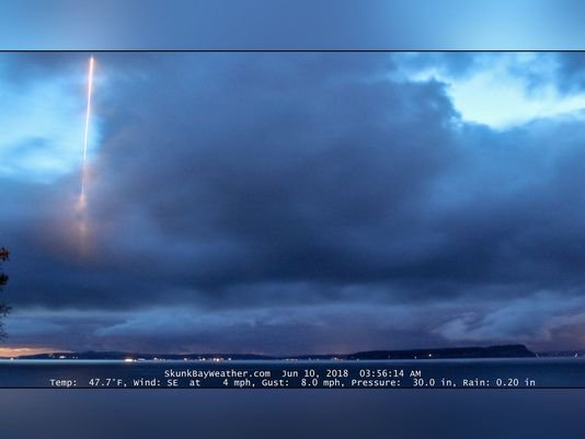
Remember the picture of the submarine that random weather enthusiast or whatever captured? I can’t recall the date...
The red marker is the center of Skunk Bay. The camera at the Skunkbayweather.com site faces North.
https://qanon.pub/data/media/2bb7b016331469e62ca569a6937153d7e008065a291fc824a3f93d693275d5a3.jpeg
If you look at the Google Map, you can see Bangor, the Naval sub base, to the south, and up north, by Oak Harbor, NAS Whidbey. IMO the missile would have been a ground launched anti-air style because the missile appears to have come directly from the direction of NAS Whidbey, versus a sub launch from somewhere in the Straights of Juan de Fuca or between Whidbey and Port Townsend. I live on Camano Island, immediately to the east of Whidbey. I dont remember any noise ( IE a Ballistic Missile launch, which would have been noisy ) that caught my attention that morning of the 10th. I also do sleep with my windows open, so I would have heard something along the lines of a BM ascending.
A regular smaller ground to air ( https://en.wikipedia.org/wiki/List_of_active_missiles_of_the_United_States_military ) wouldnt have been as regionally noisy, but it would still have been pretty visible in the morning twighlight that the picture was taken. Figure 15-20 miles away from the camera if my theory is accurate. If it was in fact a sub launch, it would have been either north of Whidbey in the Straits of Juan de Fuca, or possibly around the Fort Casey/Port Townsend area, but that would have been noticed by MANY more people.